History of Celestial Navigation
Before scientific navigation developed in Mediterranean Europe,
Indian and Pacific Ocean sailors navigated by the Sun and the stars.
 They created detailed star maps in their minds and elaborate ways of remembering them.
Arab Indian-Ocean navigators used sounds, relying on poetic verses to remember the stars and their position.
Polynesians and Micronesians, sailed hundreds of miles across the open oceans.
Lacking writing, these navigators had to rely on their knowledge of the stars, sailing directions,
seamarks, and learn to read the waves and clouds to determine currents and predict weather.
They created the most elaborate star maps and
sidereal compasses.
They created detailed star maps in their minds and elaborate ways of remembering them.
Arab Indian-Ocean navigators used sounds, relying on poetic verses to remember the stars and their position.
Polynesians and Micronesians, sailed hundreds of miles across the open oceans.
Lacking writing, these navigators had to rely on their knowledge of the stars, sailing directions,
seamarks, and learn to read the waves and clouds to determine currents and predict weather.
They created the most elaborate star maps and
sidereal compasses.
In Europe, The Phoenicians and Minoan-Greeks were the first of the
Mediterranean sailors to navigate far from land and to sail at night.
They made primitive charts and knew a crude form of Dead Reckoning.
They used observations of the Sun and the North Star (Polaris) to
determine directions.
They estimated distances from the time it took to cover them.
But none of these techniques of Celestial Navigation relied upon science.
All were good enough for navigating when the winds and currents were
predictable.
But none of these techniques were adequate for the combination of
intense storms and lengthy calms in the Atlantic.
When the Chinese developed a compass for navigation in the 11th century,
it was quickly adopted in the Indian Ocean and Europe, but not in the
Pacific area where the traditional star compasses obviously remained adequate
enough for navigation.
Dead Reckoning Navigation
Prior to the development of Celestial Navigation, sailors navigated
by "deduced" (or "de(a)d") reckoning.
This was the primary method of navigation used by mariners for a
very long time, even beyond the era of the first European "discoverers"
of the 15th century.
In Dead Reckoning, the navigator finds his position by measuring the
course and distance he has sailed from some known point marking his
new position.
Each day's ending position would be the starting point for the next day's
course-and-distance measurement.
In order for this method to work, the navigator needs a way to measure
his course, and a way to measure the sailed distance.
Course was measured by a magnetic compass, which had been known in Europe
since at least the end of the 12th century.
Before that, course was estimated from the direction of the prevailing winds
or prevailing swells.
Distance was determined by a time and speed calculation: the navigator
multiplied the estimated speed of the vessel by the time travelled to cover
the distance.
Distances and courses were accurately recorded and added over days and
weeks in order to keep track of the current position.
Latitude Sailing
Viking merchants navigated their ships - "knarr" - on regular
journeys over the north Atlantic connecting their settlements in
Norway, Iceland and Greenland.
Although they had no magnetic compass, they were able to sail
due West or due East courses by using the Sun at daytime and the
stars at night to verify their course.
From their port of departure, they would first sail along the Norwegian coast
North or South until they had reached the Latitude of their destination
and then sailed on a constant West course to their port of destination.
The prominent ice-covered mountain peaks of Iceland and Greenland
were used as landmarks to approach these coasts.
By experience, they knew approximately how long their voyages
would take so that they also applied a kind of Dead Reckoning
combined with an elaborated celestial knowledge of which
they took advantage for their constant-latitude navigation.
At the end of the 15th century, Celestial Navigation was just being
developed further in Europe, primarily by the Portuguese.
 Columbus was the first navigator that we know of who kept a detailed
log of his voyages.
It is by these records that we know how Columbus navigated, and how
we know that he was still primarily a Dead Reckoning navigator,
but we also know that he experimented with techniques of Celestial
Navigation, not for navigation itself, but for charting the new
discovered world of the west Indies.
Columbus was the first navigator that we know of who kept a detailed
log of his voyages.
It is by these records that we know how Columbus navigated, and how
we know that he was still primarily a Dead Reckoning navigator,
but we also know that he experimented with techniques of Celestial
Navigation, not for navigation itself, but for charting the new
discovered world of the west Indies.
In these early centuries of Celestial Navigation, the navigator would
observe celestial bodies (Sun, Moon and stars) to measure his Latitude.
Until the 17th century, it was impossible to determine Longitude
from celestial observations.
But even in ancient times, it was fairly easy to find the approximate
Latitude by observing the Sun and stars.
Each star has a Celestial Latitude, or Declination.
If the Declination of the star that is directly overhead (Zenith) in known,
this will be the same as the observer's Latitude on Earth.
Even if a star isn't directly overhead, if the angle
between the star and the Zenith can be measured, the Latitude can
still be determined, provided the measurement is done the time of night
at which that star gains it's highest Altitude in the sky.
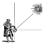
The most important tool used by Columbus in his celestial attempts
was the quadrant.
This was a metal plate in the shape of a quarter-circle.
From the center of the circle hung a weight on a string, that crossed
the opposite edge of the circle.
The navigator would sight the North Star along one edge, and the point
that the string crossed the edge would show the star's altitude,
or angle above the horizon.
In the case of the North Star, this is always pretty close to the
observer's Latitude.
 In order to find Latitude, the local time at some reference location
(e.g. the port of departure) must be known.
Time aboard the ship was measured by a sand glass.
It was the responsibility of the ship's boy to turn the glass every
half-hour in order to measure the time until the watch changed.
Since the sand glass was always running a little slow or fast,
it was checked daily against the times of sunrise, sunset, or midnight.
Midnight could be determined by using a nocturnal, a nifty little tool
which tells the time of the night by the rotation of stars around
the Celestial Pole. This system of time-keeping was, of course,
inaccurate and quite unsuitable for Celestial Navigation.
In order to find Latitude, the local time at some reference location
(e.g. the port of departure) must be known.
Time aboard the ship was measured by a sand glass.
It was the responsibility of the ship's boy to turn the glass every
half-hour in order to measure the time until the watch changed.
Since the sand glass was always running a little slow or fast,
it was checked daily against the times of sunrise, sunset, or midnight.
Midnight could be determined by using a nocturnal, a nifty little tool
which tells the time of the night by the rotation of stars around
the Celestial Pole. This system of time-keeping was, of course,
inaccurate and quite unsuitable for Celestial Navigation.
Before the invention of accurate clocks, it was nearly impossible
for mariners to find their Longitude.
This did not stop them from trying, however and over the 17th and
18th century a lot of methods were developed, most of them quite
impractical for maritime use.
The only practical method for determining Longitude in the 15th
century was the well known method of timing lunar eclipses.
This method had been in use since ancient times, but since eclipses
are rare, it is of limited use.
Also the orbiting of Jupiter's moons - discovered and documented
by Galileo Galilei in 1610 - were in use as an accurate timepiece,
but it required a large telescope to be useful.
Navigation in the 16th Century
Nuño da Silva, a Portuguese captain
and pilot whose merchant ship was captured by Francis Drake
during his epic circumnavigation of the globe in 1577 - 80,
made the following comments on Drake's skill as a navigator:
"The first thing he did when he had captured a vessel
was to seize the charts, astrolabes, and mariner's compasses ...
He carries three books of navigation, one in French, one in
English, and another, the account of Magellan's voyage, in a
language I do not know ... He is a very skilful mariner ..."
The book in English that Drake was very likely carrying aboard
the Golden Hind when he departed Plymouth, England, in 1577,
was either the first or second edition of William Bourne's
A Regiment for the Sea, published in London in 1574 and 1576,
respectively.
Bourne's "Regiment" was far and away the most current
and important English book on navigation available at the
time of Drake's departure.
As such, it is hard to conceive that Drake, the foremost English navigator
of the age, would not have been carrying it.
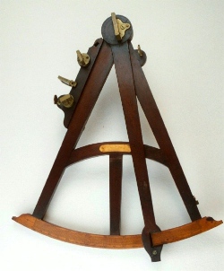
In Drake's day there were three instruments that mariners used to make celestial
sightings for use in computing their Latitude: the quadrant, the
cross staff, and the astrolabe.
The 16th-century mariner had no means for measuring Longitude.
The ability to measure Longitude practically and accurately, particularly at sea,
was created by John Harrison's invention of the sea chronometer 150 years later.
 |
|
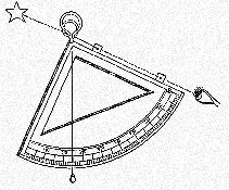
The quadrant was the first instrument
developed for use in Celestial Navigation, dating back to the 15th century.
It was a very simple device constructed of wood or metal in the form of a quarter
circle with degree graduations along the arc.
It had sights along one of the radial arms and a plumb bob suspended from the right
angle.
The observer held the quadrant with the arc straight down and looked up through the
sights at the Sun or star.
When his sights were aligned, he simply held the plumb line fixed against the face
of the quadrant between his finger and thumb and read off the altitude from the scale.
In Drake's day, the quadrant was probably most commonly employed on land to make
North Star observations. |
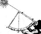
The cross staff in use in 1579 was a simple device that worked reasonably well for
measuring the angle of the Sun above the horizon at noon.
It was fitted with one movable vane (transversary) that, with the end of the staff
placed at the eye of the observer, was positioned so that it appeared to touch both
the horizon and the Sun.
The angle was then read from a scale on the staff.
In his Regiment, Bourne admonishes the navigator against using the cross staff for
measuring an altitude of over 50°, the maximum angle that the Sun and the horizon
could be taken in together with one glance.
The cross staff was the method of choice on a rocking ship since its use did not rely
on gravity. |
|
 |
 |
|
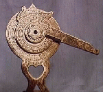
The mariner's astrolabe in common use by English seamen at the time was a wheel-shaped,
cast-brass instrument of perhaps 20 or 30 centimetre in diameter with a thumb ring
at the top.
The ring mount was designed to allow the instrument to hang vertically plumb and to
provide for precise rotational control by the user.
The disk was divided into four quadrants, two or more of which had scales divided
into 90 degrees each.
The astrolabe had a rotating sighting arm (alhidade), mounted through the center.
Though the astrolabe offered a reliable and accurate method of measuring altitude,
the mariner's ability to read the degree scales along the rim was a limiting factor
on the precision of the observation.
Since each degree division for a 20-centimetre diameter instrument was only about
2 millimetre, the mariner could read the angle only to the nearest half degree.
As with the quadrant, the mariner's ability to make an astrolabe sighting at sea could
be completely frustrated by movement of the ship. |
The astrolabe was best suited for use on land where it could be held
steady in hand or suspended from a tripod.
For his land based readings, however, Drake, may have been using a
simple astronomical ring or a larger astrolabe such as a 60-centimetre
diameter instrument known to have been produced in England by
Humphrey Cole in 1575.
Due to their size and weight, these larger instruments were not
practical for use at sea.
With the stable foundation and larger scale (5.2 millimetre per
degree for a 60-centimetre ring), the mariner could easily make
his altitude readings to the nearest quarter of a degree and could
at least attempt readings to the nearest 10 minutes of arc.
To convert the instrument altitude into a position of Latitude,
Drake first needed to correct for any instrument error (index error)
to obtain what is called the observed altitude.
The astrolabe was easily checked for index error by rotating the
instrument 180 degrees, taking sightings from opposite directions,
halving any difference detected, and then adding or subtracting
this value from the reading.
With the observed altitude at hand, Drake would turn to his
astronomical almanac.
This would contain the tables of changing but predictable
astronomical events (ephemeris) useful to the mariner that
were then called a regiment.
William Bourne's 1574 A Regiment for the Sea, contains
tables of ephemeris,
including those for the Declination of the Sun north or south
of the equator for four-year cycles including leap year, and
covers the years 1573 through 1592.
The use of these declination tables introduced some errors in the
measured positions logged in Drakes publications:
First, Bourne's declination tables published in 1574 contained
errors which are due in part to the apparent slow and swift
motions of the Sun between the solstices and equinoxes.
These slow and swift motions were not fully explained until Kepler's
laws of planetary motion.
The resulting errors in the declination tables were in the order of
10 minutes of arc; smaller near the summer and winter solstices
and larger in between.
Secondly, Bourne's declination tables, which were derived for London,
had to be corrected for Longitude when used anywhere significantly
east or west of London.
Mariners in 1579, however, with no way to measure their Longitude
presumably ignored the problem.
We know for certain that Drake did not correct his Declinations
for Longitude because when having sailed 360° and returning
to Plymouth, he found his reckoning to be one whole day off.
According to the last paragraph of "The World Encompassed",
the day of his return was
"Monday in the just and ordinary reckoning of those that had
stayed at home in one place or country, but in our computation
was the Lord's Day, or Sunday."
Sight Reduction
Sight reduction is the process of deriving a line of position
from an observed altitude and the coordinates of the observed
celestial object.
This entails computing the object's altitude and bearing, using
either the estimated or an assumed position.
As we know it, sight reduction is a comparatively recent development,
whether the computations are made by log tables or sight reduction tables;
the concept of the position line dates back only about 140 years.
For centuries, the only sights the navigator could use were those of
bodies transiting his meridian; from these he could obtain his Latitude.
Otherwise, with the exception of Polaris, which served to indicate
Latitude and direction in the Northern Hemisphere, without an accurate
time source, the celestial bodies were of little use except as
steering reference.
The need for developing a method of determining Longitude became
ever more urgent as longer voyages of commerce and exploration
were undertaken.
During the 15th through the 18th centuries, the best mathematical
and scientific minds in Europe worked on this problem.
It was known that the apparent motion of the heavenly bodies was
extremely regular, and that the Moon changed its position
relative to the Sun and the stars at a constant rate.
It was apparent, therefore, that there were two possible solutions;
either the Moon must be made to furnish time, and therefore Longitude,
or an accurate time piece must be designed and built.
The latter choice was long unattainable; the great majority,
therefore, turned their attention to the Moon.
The Moon's rate of motion, as it crosses the sky, differs by
roughly 30' per hour, about the Moon's diameter - or 12° per day -
from the motions of the Sun and stars.
If the exact angular difference between the center of the Moon
and the center of some other celestial object could be measured,
the time of the observation, and therefore the Longitude,
could be determined.
The first determination of Longitude by lunar distance is
variously attributed to Regiomontanus in 1472, Amerigo Vespucci
in 1497, and John Werner in 1514.
However, for centuries it was very little used, because of lack
of accurate ephemeral data on the Moon, poor instruments, and
the complexity of the necessary computations.
In 1675 the Royal Observatory was established at Greenwich, England,
and accurate ephemeral data on the Moon were slowly accumulated there,
as well as at various observations on the Continent.
In 1767 the English Nautical Almanac appeared, combining much
astronomical data in a single source.
Incidentally, this publication eventually led to the universal
adoption of the meridian of Greenwich as the prime meridian
for establishing Longitude.
In 1884, this was established by an international agreement.
Prior to that, all of the seafaring nations had their own
"Prime Meridian", causing Longitude to be different on charts
created in different countries.
The advent of the Nautical Almanac facilitated the working of
lunar distance observations,
and the invention of the sextant in 1730 made it possible to
obtain such observations with considerable, accuracy.
|
On his first voyage to the Pacific, 1768-1771, Captain James Cook did not carry a chronometer,
and determined his Longitude by lunar distances.
In 1769-1770 he charted New Zealand with remarkable accuracy.
Observations were all made afloat by Cook, himself, and Charles Green, an astronomer,
using Hadley sextants.
John Hadley (1682-1744), an optician by trade, built a reflecting octant in 1731,
based on a sketch of Newton.
This instrument prefigured the modern nautical sextant.
Although, measured by our standards, these instruments used by the Cook exploration were
quite primitive, the Latitudes obtained were all fairly accurate.
The measured Longitudes were somewhat more uncertain - the South Island was placed
about 25', or 18 miles, too far to the East.
Nevertheless, the maximum error in the obtained Longitudes was only about 40', or 28 nautical miles.
|
The lengthy mathematical calculations involved in lunar distance
observations deterred many navigators from making use of this
method and the bait of coming to the Latitude of the vessel's
destination, and then sailing due East or West to the port,
remained in wide use.
Only after the simplification of the lunar method by
Nathaniel Bowditch in 1802, the use of lunar distance observation
was considerably widened.
Even with a chronometer on board, lunar distance observations
continued to be used in isolated areas as a check on chronometers
until the invention of radio.
The lengthy tables of "Maritime Positions," listed in Bowditch
through the 1962 edition, were included primarily to permit
checking the accuracy of the chronometer by means of celestial
observations.
John Harrison developed a prototype chronometer in 1720, and
submitted a perfected instrument to the Royal Navy for sea
trials in 1735.
Improved models were produced by him over the next 40 years;
they ran well, but were extremely expensive, and their use was
long highly restricted.
Only in this century did the chronometer come into wide use,
greatly facilitating the determination of Longitude.
The invention of radio permitted a regular and easy check on
its accuracy.
With the invention of the chronometer, when the Latitude was
known, it became possible to compute the Longitude, using the
time sight method.
This method of navigation remained popular into this century,
as a position could be determined without plotting.
 |
|
The discovery of the line of position by Captain Thomas H. Sumner
in 1837 heralded a new era in navigation.
The Sumner line of position
was originally obtained by reducing the same sight twice:
the estimated Latitude was used for the first reduction.
A slightly different Latitude, say, 10' or 20' from the first,
was then selected to reduce the sight a second time.
A line of position was then drawn through the two positions
on the chart.
With the invention of azimuth tables in the latter part of the
nineteenth century, it became possible to work out only one
time sight, and then draw a line through the resulting position,
perpendicular to the object's azimuth. |
The era of the "new navigation" came with the introduction of
the altitude-difference method of determining a line of position
by Commander Adolphe-Laurent-Anatole Marcq de Blonde de Saint-Hilaire,
of the French Navy, in 1875.
This method remains the basis of almost all Celestial Navigation
used at sea today.
The approach is to solve the problem backward to simplify
the calculation.
Instead of using the observed data to locate the observer directly,
an assumed position is used as a reference and the altitude and
bearing is calculated for this assumed position.
This calculated altitude is then compared to the observed altitude.
The altitude-difference gives the distance between the point of
observation and the assumed position yielding a line of position.
The Marcq Saint-Hilaire method, as it is generally called,
remained in common use on board of military and merchandising
ships through the first decades of the 20th century and remains
the basis of almost all Celestial Navigation used at sea today.
Computed altitude and azimuth angle were calculated by means of
the log sine, cosine, and haversine, and natural haversine tables
included in Bowditch.
Subsequently sight reduction was greatly simplified by the coming
of the various so called short-method tables - such as the
Weems Line of Position Book, Dreisonstok's H.O. 208,
and Ageton's H.O. 211.
Even greater simplification was achieved when the inspection
tables, H.O. 214, H.O. 249, and H.O. 229, were published.
The final step is use of the (programmable) electronic calculator.
However, the wise navigator will always have familiar back-up
methods to rely upon if necessary; he may even need to find his
Longitude by a lunar distance observation on occasion.
Sources
|