Basic Instruments for Celestial Navigation
In order to be able to find the exact coordinates of the celestial objects
in the sky - which are used as reference points to determine position -
it is essential to know the exact UTC-time at the moment of measuring
celestial altitudes.
Therefore, a marine Chronometer is part of the
Basic Instruments for Maritime Navigation. |
 |
|
Besides a marine Chronometer, the instruments for Celestial Marine
Navigation consist of devices to measure the "position" of the object in the sky.
The position of an object in the sky in the coordinate system of the navigator is characterized
by the "Azimuth" (bearing) and the "Altitude" of a celestial object.
The Altitude is the angle between the object in the sky and the plane of the
apparent or visible horizon.
Today a Sextant is used for such a measurement.
It was developed from more ancient instruments such as the astrolabe, the cross staff and the
quadrant.
|
The Marine Sextant
A marine sextant is a high-precision optical instrument designed
for measuring angles between two points.
It is based on bringing to coincidence the direct ray of one point
and the double reflected ray of the other point.
Typically the sextant is used to measure the height of a
celestial object above the observers visible horizon.
This angle is called "the altitude of the celestial object"
or simply "Altitude".
A marine sextant can measure angles with a precision of less than 0.5',
better than 1/100 th of a degree.
The sextant basically consists of two mirrors: a fixed horizon
mirror and a rotatable index mirror. The mirrors are mounted on a frame.
The frame consists of an arc of a circle, marked off in degrees,
and a movable index arm (alhidade) pivoted at the center of the
circle.
|
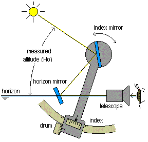 |
A telescope, mounted to the frame, is lined up with the horizon
as observed through the half transparent (or split view) horizon mirror.
The radial arm, on which the index mirror is mounted, is moved such
that the observed celestial object is reflected into the small
mirror and appears, through the telescope, to coincide with the
horizon.
The angular distance of the celestial object above the horizon
can then be read from the graduated arc of the sextant.
The fundamental principle of celestial navigation is that
this angular distance is directly related to the distance
from the observer to the Geographic Position of the sighted object.
In order to make precise measurements, the alhidade can be
moved with a threaded drum spinning in a worm thread fixed
to the frame of the sextant.
The drum has a minute scale and a vernier permitting a
reading of the measured angle down to a tenth of a minute.
To achieve this precision, a sextant is build from high precision
mechanical parts made from a special temperature-compensating alloy.
The instrument should be handled with adequate care which is also
the reason why sextants are normally kept in noble wooden boxes.
|
Sextant handling for Altitude Measurements
Index Error
The index error of a sextant is caused by a slight mirror
misalignment resulting in both mirrors not being exactly
parallel when the index arm is set exactly to zero.
This causes a systematic error on all readings from the
index.
Therefore, the index error of the sextant should be determined
carefully before each set of altitude measurements:
Set the index arm with the micrometer drum to the zero reading
on the index scale and select an appropriate shade glass in the
direct sight line to observe the visible horizon. Hold the sextant vertically and direct the sight line at the
horizon while looking through the telescope. Adjust the sextant as necessary to cause both images of the
horizon to come into line. The sextant's reading when the horizon comes into line is the
index error.
Notice that the index error can be positive or negative!
It must be subtracted with it's correct sign from each sextant reading.
Sun Sights
Before pointing the sextant to the Sun and looking through the
telescope, put the appropriate shade glass into the reflected line of sight!
Hold the sextant vertically and direct the sight line at the
horizon directly below the Sun and move the index arm outward
along the arc until the reflected image appears near the
direct view of the horizon.
Rock the sextant slightly around the telescope axis and adjust the
index arm such that the image of the Sun will exactly touch
the horizon as it moves in an arc above the line of the horizon.
An alternative technique is to let the Sun contact the line of the
horizon by its own motion, bringing it slightly below the horizon
if rising, and above if setting and then wait for the moment of
contact without further adjustment of the index arm.
At the instant of contact the navigator will record the exact time
and read the altitude from the index.
Observation of the Sun are normally done using the lower limb,
but depending on the visibility of the Sun, also the upper limb
may be used for Altitude measurements with basically the same procedure.
Moon Sights
When observing the Moon, the phases of the Moon will determine
which of the two limbs are suited for an Altitude measurement.
On some rare occasions, when the shadow line of the Moon
is nearly vertical, it may be difficult to select the
appropriate limb to make an accurate sight.
Sight of the Moon are best made during daylight or twilight
hours.
At night, false horizons may appear because the Moon illuminates
only a part of the sea below it.
Planet Sights
Planets and stars can only be sighted
during the twilight hours when the line of the horizon can
still be clearly determined.
Planets and starts are so far away, that even
through the telescope of the sextant no difference between
upper or lower limb can be detected.
Notice, that also the planets show phases similar to the Moon
and that "choosing" the wrong limb may result in inaccurate
Altitude values.
But generally, these errors are too small to be noticed and
can be ignored.
Making sights of small bodies such as planets and stars requires
a certain level of practising.
One technique, which prevents "loosing" the sighted object from
the telescope is to first hold the sextant upside down and
direct the line of sight to the object.
Then slowly move the index arm until the horizon appears in the
telescope.
Keep this setting and turn the sextant in the normal position again.
Now the fine adjustment can be done in the usual manner.
Corrections on Sextant Measurements
The methods generally used today for Celestial Navigation,
are based on the comparison of an "observed altitude" (Ho) with a related
"computed altitude" (Hc).
The computed altitude is based on a mathematical model implying a number
of conditions and assumptions some of which are:
The celestial bodies have no physical dimensions and observations are
made from the center of the Earth. Light rays from celestial bodies come from infinitely far away and hence
reach the Earth parallel to one another. The Earth has no atmosphere and air has no index of refraction.
These assumptions are not full-filled for observations made in the physical world.
In order to put the mathematically computed altitude and the "real world"
observed altitude on an alike basis of comparison,
some "corrections" must be applied to the measured sextant altitude.
These corrections are performed on the measured sextant altitude according
to the following scheme:
  Hs     __ ° __'_                Sextant Altitude
  IE   ±      __'_                Index Error
  dip  -      __'_                Dip Correction
       _____________
  Ha     __ ° __'_                Apparent Altitude
  Refr -      __'_                Refraction
       _____________
         __ ° __'_
  Prlx + __ ° __'_     HP __°_    Parallax Correction
  SD   ±      __'_     SD __'_    Semi-Diameter Correction
       _____________              (lower limb:+ /upper limb:-)
  Ho     __ ° __'_                Observed Altitude
|
The sextant altitude (Hs) corrected for index error (IE) and dip correction (dip)
is called "apparent altitude" (Ha).
This value is used as entry for further corrections (refraction (Refr) and parallax (Prlx) ).
The values for "semi-diameter" (SD) and "horizontal parallax"
(HP) must be obtained from the Nautical Almanac.
The required values for the correction of dip, refraction
and parallax can be found in the pre-compiled
correction pages (125 Kbyte PDF file),
or they can be obtained from the
Interactive Correction Tables for Sextant Altitudes.
|