Celestial Navigation
 |
Celestial Navigation is a very elaborate system.
It took literally centuries and generations of navigators, astronomers,
mathematicians and instrument makers to develop, not reaching
its present form until 1877.
In the early ages of maritime navigation long before the magnetic
compass emerged, the Sun and some selected stars were used as
an aid for orientation to check and correct courses.
Viking navigators explored the northern Atlantic region between
Norway and Canada navigating mainly by the Sun at daytime and
by some circumpolar stars at night.
|
Later, as more precise ephemeral data became available and
improved optical measurement instruments had been developed,
celestial objects could also be used for determining a position
at sea.
Different methods were then derived to find a Line-of-Position
from a measured Altitude.
This procedure is called "Sight Reduction".
The first of such methods was developed in 1835 by the American
captain Thomas Sumner.
The method of finding a position from a measured Altitude used
today, is called "Altitude-Intercept Method" and it was developed
in 1875 by the French navy commander Adolphe-Laurent-Anatole
Marcq de Blonde de Saint-Hilaire.
This technique is based on calculating the Altitude of a celestial
object at the estimated position and compare this
calculated Altitude (Hc) with the measured Altitude
(Ho) of that object.
The Altitude difference (intercept = Hc - Ho) is directly related
to the distance between the estimated position and the location of
observation, eventually yielding a Line-of-Position (LoP).
|
The Principle of Celestial Navigation
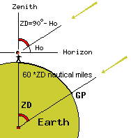
The Altitude of a celestial object Ho is the angle
- measured by an observer on Earth - between the object
and the horizontal plane in the location of the observer.
If a celestial object is in the Zenith of the observer,
its Altitude would be 90°.
In this case, the observer would be at the GP of the object.
If the observer is some distance away from the GP of the object,
the measured Altitude is less than 90°.
It will be less than 90° by an amount proportional to the
distance from the GP.
Any distance on Earth, translates into an angle by the following
relation:
1 Nautical Mile = 1 minute of arc on a
great-circle segment.
In the same way angles translate into distances.
The picture on the right shows the situation, in which the observer
is a distance "ZD" away from the GP of the observed celestial object.
If ZD is expressed in degrees, the distance in nautical miles is:
Distance [nm] = 60 * ZD [°]
|
 |
The Altitude Ho measured by the observer in a location, which is a
distance ZD away from the GP of the observed celestial body will be:
Ho [°] = 90° - ZD [°]
On the other hand, by measuring the Altitude of a celestial body,
the great-circle distance between the GP of the observed object and
the location of observation can be determined:
ZD [°] = 90° - Ho [°]
The Zenith Distance ZD, resulting from a sextant measurement, is both
the earth-bound angular distance between the GP of the observed
celestial body and the location of the observer, as well as
the angular distance on the celestial sphere between the position
of the celestial object and the Zenith of the observer.
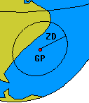 |
All zenith points with a given "ZD" distance from a celestial object,
are on a circle on the celestial sphere centred on the location
of observed object.
The radius of this circle - in degrees - is equal to "ZD".
A similar circle on the Earth can be constructed.
From any point on this circle, the observed Altitude "Ho" of
this celestial object would have the same value.
Hence, it is called Circle-of-equal-Altitude.
Its center is the GP of the celestial object.
The radius of the circle is the Zenith Distance "ZD".
If also the Azimuth of the observed object (the direction
referred to true North in which the object in the sky is sighted)
could be measured, it would be possible to determine the observers
position from a single observation.
|
|
On a moving vessel, it is not possible to measure the Azimuth with
appropriate precision to use it for the determination of the position.
The Azimuth Line must be drawn away from the GP towards the observer
and as the radius of the Circle-of-equal-Altitude may be very large
(one degree of Zenith Distance corresponds to 60 nautical miles),
small errors on the Azimuth angle will result in large position errors.
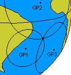
But by measuring the Altitude of another celestial body,
a second Circle-of-equal-Altitude can be constructed (centred on the
GP of a second celestial object).
Ordinarily, both circles would intersect in two widely separated points.
One of these points would be the position of the observer.
Ideally, a third observation will yield a unique position with
the intersection of three Circles-of-equal-Altitude.
|
 |
To put this theory into practice, a navigator measures the Altitudes of
two or more celestial objects.
Also the exact time (down to the second) at which the observations
were done must be known.
For this purpose accurate clocks called chronometers are needed.
These are kept set to Universal Time (UT), as this is the time
used in the Nautical Almanac.
The Nautical Almanac is a book of astronomical tables containing
the positions (on the celestial sphere) of the Sun, the Moon,
the planets and the stars used for celestial navigation.
The positions are recorded in Declination and GHA.
From these celestial positions, the Latitude and Longitude
of the GP's of the sighted objects at the time of observation
may be found.
Knowing the Altitudes of the observed objects and their GP's
at the time of observation, the navigator - theoretically -
has all the information necessary to construct the
Circles-of-equal-Altitude from which eventually the position
may be derived.
Actually, the navigator cannot plot the full circles -
unless he is close to the GP of the observed celestial body.
Otherwise, not only very large charts would be required, but also the
latitude-dependent scaling factor of the Mercator chart must
be taken into account.
Due to this, a Circle-of-equal-Altitude will not be a circle
in the projected chart - especially not if it covers a large range
of Latitude.
Circles-of-equal-Altitude cannot be easily constructed
on a Mercator chart.
But fortunately, these Circles-of-equal-Altitude are usually so
large that on reasonably scaled charts, only a small segment
of the circle must be drawn.
Moreover, the segments of these circles are so short that
- without practical loss of accuracy - they can be drawn
as straight lines.
Like the lines obtained from bearings in piloting, a segment of a
Circles-of-equal-Altitude is also called a Line-of-Position (LoP).
The Sumner Line-of-Position
Since Circles-of-equal-Altitude cannot be directly plotted
on a nautical chart, methods had to be developed to obtain
a Line-of-Position from a measured Altitude.
This process is called "Sight Reduction" and is was only after
these methods had been developed and established among navigators,
that Celestial Navigation was augmented to a true method of
navigation enabling of determining a position only by the
measuring the Altitude of celestial bodies.
After chronometers became available and affordable for maritime
navigation, a method called "time sight" was used to obtain
the Longitude information from the Altitude of the Sun.
One practical problem with the "time sight" is that it requires
the knowledge of the Latitude, which had to be obtained from
dead reckoning, which remained the primary navigation method
throughout the 19th century.
In 1837, after having sailed 600 Miles through rain and fog over
the Atlantic and entering the passage between Ireland and Wales,
captain Thomas Sumner was able to measure a single Altitude during
a short spell of sunshine.
He then had to consider how to extract the most information possible
of this single Altitude measurement to improve the knowledge on his position
considering that his dead-reckoned Latitude would be very unprecise.
For the problem posed by this situation he developed a new method
of constructing a Line-of-Position for a measured Altitude, which
enabled him a safe journey to his destination.
Later, Thomas Sumner was able to derive a more general method for this
method of Sight Reduction, which is still valid today.
It is known as The Sumner Line-of-Position
and starts from an assumed Latitude obtained e.g. by dead reckoning.
The Altitude-Intercept Method of St. Hilaire
About 40 years after Thomas Sumner had found his method to construct
a Line-of-Position from an arbitrary Altitude measurement, an even
more general method was developed by the French navy commander
Adolphe-Laurent-Anatole Marcq de Blonde de Saint-Hilaire.
The method is called "Altitude-Intercept Method" and after 1885
this became the most practical method to find a
position by celestial observations.
The Altitude-Intercept Method starts from the fact that a navigator
normally has a good estimation of his Assumed Position (AP)
- e.g. by means of Dead Reckoning.
From the knowledge of the celestial coordinates
of a sighted celestial object, the navigator can calculate
the Altitude and the Azimuth of the celestial object at the
time of his observation in the Assumed Position.
This process of calculating the Altitude (and Azimuth) of a
sighted object for the time of observation at the Assumed Position
is called "Sight Reduction".
On the chart, the Assumed Position is plotted - if not already available
through the Dead Reckoning navigation process.
Through the Assumed Position, the Azimuth line may be drawn.
This Azimuth line is the line of direction pointing to the GP of the
sighted celestial object. |
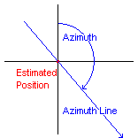 |
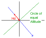
Perpendicular to the Azimuth Line a part of the - approximated -
Circle-of-equal-Altitude can be drawn as a straight line.
This line is a Line of Position if the navigator were exactly on the
Assumed Position.
In this case the measured - or "observed" - Altitude (Ho) would
equal the calculated Altitude (Hc).
If the observed Altitude (Ho) differs from the calculated Altitude (Hc),
the altitude difference (Hd = Ho - Hc) can be used to
translate the Circle-of-equal-Altitude
(through the Assumed Position) along the Azimuth Line,
such that the translated Circle of equal Altitude
corresponds to the measured Altitude.
The required translation is quite simple: the altitude difference (Hd),
expressed in minutes of arc, is equal to the number
of nautical miles by which the Circle-of-equal-Altitude has to be
moved "up" or "down" the Azimuth Line.
The sign of the altitude difference gives the direction
("away from" or "towards" the GP) in which the Circle-of-equal-Altitude
must be moved.
i.e. if the measure Altitude is greater than the calculated one
by e.g. 13 minutes of arc, the Circle-of-equal-Altitude must be moved by
13 nautical miles towards the GP of the celestial object,
and if the measured Altitude was less by e.g. 7 minutes of arc
than the calculated one, the Circle-of-equal-Altitude must be moved away from the GP
by 7 nautical miles. |
 |
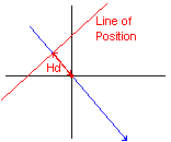
Finally the translated Circle-of-equal-Altitude (which must be approximated
by a straight line at a right angle to the Azimuth Line)
is the Line of Position (LoP), corresponding to the observed Altitude.
As for each LoP, the navigator only knows that he is located
somewhere on this line.
A second LoP will eventually allow a position fix.
The second "celestial" LoP may be obtained by a second observation
of a different celestial object or by the observation of the same
object a few hours later.
Provided the navigator hasn't moved during his observations,
he is at the intersection of the two LoPs.
If the navigator has changed his position between two Altitude
measurements, the original LoP has to be "advanced" over
the direction and distance he has travelled (as in terrestrial piloting).
The position will be at the intercept of the last LoP
and the advanced - older - LoP. |
 |
As mentioned, the obtained Lines-of-Position are in fact circles
centred around the Geographic Position of the observed object at
the time of observation.
These circles are usually so large that is suffices to draw the
tangent to the circle as position line.
However, in tropical regions, where the Altitude can reach 90°,
the circles can be very small!
In this case it may well be possible to draw the Circles-of-equal-Latitude
directly into the chart and a position can be obtained
by the following method:
take several observations when the Sun is nearly dead overhead
(e.g. over a 15-minute period).
For each observation, plot the coordinates (GHA,Dec) of the
sub-solar point (GP) on the chart and draw a circle of radius equal
to the Zenith Distance (90° - measured altitude).
Over the 15-minute period you will probably have collected 3 or 4
observations, so you would be able to draw 3 or 4 circles who would
all intersect (more or less) at one point.
This method is simple but effective especially as in the tropics,
Lines-of-Position usually end up running all almost North-South
giving good Longitudes but bad intercepts and large errors
in Latitude.
In this situation, the traditional Noon Sight
may be important to obtain reliable Latitude information.
|