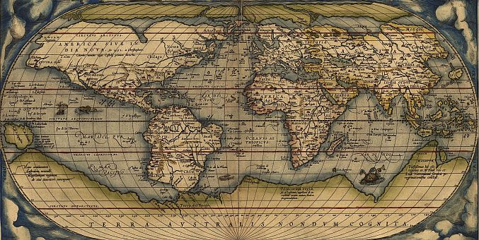
On May 20, 1570, Gilles Coppens de Diest at Antwerp issued Ortelius'
Theatrum Orbis Terrarum,
the "first modern atlas" consisting of a set of 53 maps.
It's success can only be estimated from the many editions that were published in the following decades:
three Latin editions (besides a Dutch, a French and a German edition) appeared before the end of 1572;
twenty-five editions came out before Ortelius' death in 1598;
and several others were published subsequently, as the atlas continued to be in demand until about 1612.
In 1573 Ortelius published seventeen supplementary maps under the title
Additamentum Theatri Orbis Terrarum.
Four more
Additamenta were to follow, the last one appearing in 1597.
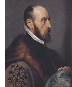
In his
Theatrum Orbis Terrarum Ortelius has combined in a systematic manner all
recent maps of the world and separate countries, of which he had heard during his long
activity as trader and collector.
Where several maps of one country were available, he chose the most modern and most reliable copy.
When the name of the author was mentioned on the map, Orteius did not change a line or a name then,
but, when the author's name was not given, he resolutely made such changes as appeared to him necessary.
He conscientiously gave credit to the author of maps which were published on a reduced scale by himself.
Considering geography as an eye of history (
historioe oculus), he usually added the ancient historical
names of countries and cities to the modern ones.
To the atlas he appended a geographical dictionary which contained both the ancient and modern names.
More important for us than this dictionary is the appended catalogue of maps
("
Catalogus auctorum tabularum geographicarum"), in which appear the names and works of ninety-nine
cartographers who lived before 1570.
As concerning many of these cartographers we have no other knowledge than that contained in this catalogue,
and as Ortelius utilized but forty-six of the maps mentioned by him, this little list is to-day one of the
most important sources for a history of cartography.
In 1593 there were 137, in 1612 no less than 166 maps, while the list of authors reached 183 for the time up
to 1595; antiquated maps were replaced by more modern ones, or changed according to the more accurate reports
forwarded for the most part by missionaries, and it soon appeared not only in the Latin language, but
also in Dutch, German, Italian, and French translations.
Very numerous were the smaller editions and extracts in the various languages.
As late as 1697 there appeared in Venice a "
Teatro del Mondo di Abramo Orteio".
As the "
Theatrum" had been dedicated to the Spanish king Philip II by Ortelius,
the latter was given the title of a Royal Geographer ("
Geographus regius").
His contemporaries honoured him as the "Ptolemy of his century".