Gerardus Mercator (1512-1594)
With the expansion of sea trading, cartography flourished from the increasingly
detailed geographical information European navigators gathered on their voyages.
Cartographers not only had to deal with the increasing amount of new data,
they also had to think of how to map this data on a chart such that it could be
most practically used for marine navigation.
Gerardus Mercator was a Flemish cartographer who developed a
"Conformal Projection" for this purpose.
The projection was mathematically based and the Mercator maps gave much more accurate
maps for world-wide navigation than any until that date.
Mercator published the first maps using his new developed projection in 1569,
but only in the beginning of the 17th century, after 1599 when Edward Wright published
a detailed explanation of the technique Mercator used, the conformal Mercator Projection
became popular among nautical cartographers.
The development of the Mercator projection represented a major breakthrough in the nautical
cartography of the 16th century.
An interesting fact of the Mercator Projection is that the underlying mathematical framework
including logarithms (developed by Napier around 1610) calculus (developed by Leibnitz
and Newton around 1660) and differential geometry (developed by Gauss around 1800) was
not yet available at the time Mercator developed his techniques for his conformal projection.
| 1512 |
|
Gerard De Cremer was born on March 5, in 1512, Rupelmonde, Flanders (in Belgium).
Mercator's family had moved from Germany to Flanders shortly before he was born.
Although his parents were not wealthy, Gerard began attending school in Rupelmonde
at an early age, where he learned Latin, religion and arithmetic.
By the time he was seven years old he was able to speak and to read Latin fluently.
After his parents had died when he was still a child, Gerard was raised by his uncle's
family, which lived in 's Hertogenbosch (in the Netherlands) where he came in contact
with the ideas of Renaissance humanism and protestant reformation.
|
| 1530 |
|
In 1530 he entered the
University of Leuven (Belgium)
to study the humanities and philosophy and graduated at the age of 20 with a
"magister artium" degree in philosophy of in 1532.
When Gerard enrolled at the University of Leuven in 1530, he translated his name into Latin
- as was the fashion at that time - and became Gerardus Mercator. |
| 1532 |
|
After graduating, he spent about two years in Antwerp, which was then the economic and cultural
centre of the Low Countries.
The reason why Mercator left Leuven is not clear, but it probably had to do with
his dissatisfaction at the university's rigid adherence to the age-old teaching of Aristotle.
The prevailing view of the world was partly determined by this teaching, which had been
added to by, among others, the Greek astronomer Ptolemy in the second century.
However, new discoveries, scientific research, recent publications, the search for new trade routes,
and so forth, were changing this traditional view rapidly.
Mercator eventually went back to Leuven to study mathematics, but he did not return to the
University.
He wanted to acquire a practical knowledge, rather than a theoretical one.
Religious doubts assailed him about this time, for he could not reconcile the biblical account
of the origin of the universe with that of Aristotle.
After two years of study which led him to Antwerp and Mechelen he emerged from his personal crisis,
fortified in his faith, with less enthusiasm for philosophical speculation.
Moreover, he brought back to Leuven a freshly acquired taste for geography.
Under the guidance of Gemma Frisius, the leading theoretical mathematician in the Low Countries,
who was also a physician and astronomer, Mercator mastered the essentials of mathematics,
geography, and astronomy.
Frisius and Mercator also frequented the workshop of Gaspar Myrica, an engraver and goldsmith.
The combined work of these three men soon made Leuven an important centre for the construction of
globes, maps, and astronomical instruments. |
| 1534 |
|
In 1534 Mercator married Barbara Schellekens, by whom he had six children.
By the time he was age 24, Mercator was a superb engraver, an outstanding calligrapher,
and a highly skilled scientific-instrument maker.
At the order of Charles V (1500-1555), Mercator made a complete set of instruments of
observation for the emperor's campaigns.
When these were destroyed by fire in 1546, another set was ordered of the same maker.
In 1535-36 he cooperated with Gaspar Myrica and Gemma Frisius in constructing a terrestrial
globe and in 1537 its celestial counterpart.
During that period he also began to build his reputation as the foremost geographer of the
century with a series of printed cartographic works: in 1537 a map of Palestine, in 1538 a map
of the world, and about 1540 a map of Flanders.
His world map of 1538 for the first time showed Asia and America as separated continents.
As usual those days, Mercator didn't travel himself, but instead collected his information from
navigators and traders, which he met in the harbour of Antwerp.
In 1540 he also published a concise manual on italic lettering, the
"Literarum Latinarum quas Italicas cursoriasque vocant scribende ratio",
for which he engraved the wood blocks himself. |
| 1544 |
|
Mercator was charged with heresy in 1544 on the basis of his sympathy for Protestant beliefs
and suspicions about his frequent travels.
He was in prison for seven months before the charges were dropped - possibly because of
intervention from the catholic university authorities.
Despite his problems with the religious authorities, he obtained a privilege to print
and publish books and was free to continue his scientific studies. |
| 1552 |
|
But because of enduring conflicts with the spanish inquisition, Mercator decided to leave Flanders
and in 1554, at the age of 42, he moved to Duisburg in the Duchy of Cleve.
He assisted the duke in establishing a grammar school by helping to design its curriculum.
After establishing a cartographic workshop and engaging his own engravers, he returned to his main interest.
In 1554 he published a map of Europe that he had begun at Leuven, and between 1559 and 1562 he taught
mathematics in the grammar school.
Through his contacts to his friend and colleague Abraham Ortelius,
who continued his cartographic work in Antwerp, he was able to update his maps with the latest
explorations of Sir Francis Drake and other contemporary Navigators who had explored the eastern
trading ways around the African continent to India and China.
During these busy years he also undertook genealogical research for Duke Wilhelm, drew up
a Concordance of the Gospels, and composed a detailed commentary on the first part of the Letter of
Paul to the Romans.
In 1564 he completed a map of Lorraine and another of the British Isles.
Public recognition of his accomplishments came in 1564 with his appointment as court
"cosmographer" to Duke Wilhelm of Cleve.
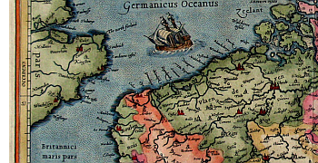
During these years he perfected his projection, which enabled mariners to steer a course over long
distances by plotting straight lines without continual adjustment of compass readings.
This technique immortalized his name in the "Mercator projection" on which parallels and meridians are
rendered as straight lines spaced so as to produce at any point an accurate ratio of latitude to longitude
This technique was first used on his map of the world in 1569. |
| 1570 |
|
Mercator then began to execute a series of publications intended to describe the creation of the world and its
subsequent history. He encouraged Abraham Ortelius to compile the first modern world atlas
- Theatrum Orbis Terrarum - published in 1570.
This "Atlas" - a term introduced by Mercator and Abraham Ortelius, which is still
used to indicate a collection of maps - was never fully realized.
In 1569, as the first section, he published a chronology of the world from the Creation to 1568.
He then published 27 of the maps originally prepared by the Greek geographer Ptolemy, with corrections
and commentary in 1578, under the title
" Tabulae Geographicae C. Ptolemei ad mentem autoris restitutae et emendatae".
The next part of the Atlas, consisting of a set of new maps covering France, Germany, and the Netherlands,
came out in 1585, with maps of Italy, "Sclavonia" (now the Balkan countries), and Greece following in 1589.
A last section, on the British Isles, was included in an edition with the previous sections, which was seen
through the press after his death by his son in 1595.
Another printing followed in 1602, and further maps were added in a later edition of 1606, usually called the
"Mercator-Hondius Atlas."
|
| 1594 |
|
Following his move to Duisburg, Mercator never left the city again and died there in december 1594 at the
age of 82, a respected and wealthy citizen.
Besides his famous projection, Gerardus Mercator excellently collaborated with Abraham Ortelius in helping
to free geography of the 16th century from the dominance Ptolemy's ideas had had up to then.
His maps and instruments are noteworthy for its delicate precision and admirable execution in detail.
|
|