Distance and Speed
In maritime navigation, distances are measured in nautical miles(nm).
The length of a nautical mile is closely related to the dimensions of the Earth.
Smaller distances may be expressed in "cables", 1/10th of a nautical mile.
Meridian Distance
Principally, units that are used to measure physical characteristics are based on
international conventions, which will define some kind of reference for the
underlying unit.
In the wake of the French Revolution, a commission organised by the French Academy of
Sciences and charged with determining a single scale for all measures, advised the adoption
of a decimal system (1790) and suggested a basic unit of length equal to one ten-millionth
of the distance between the North Pole and the Equator, to be called mètre ("measure").
The National Convention adopted this proposal in 1793.
Fifty years earlier, through the years 1735 - 1744 a series of French
geological expeditions had "measured" the length of the quarter meridian passing through
Paris as equivalent to 10 000 km.
The sea mile was historically defined as a minute-of-arc along a meridian of the Earth,
making it's length approximately 1852m.
The use of this angle-based length was first suggested by the English mathematician
Edmund Gunter (1581-1626).
In the 19th. century, the length of the sea mile was redefined and
based on the length of the Earth circumference around the Poles as determined
by Bessel in 1841. Bessel found that the Earth circumference around the Poles
was 40 003 km, yielding 1.851991 km for a nautical
mile:
1 nm = 40 003 km / (360*60') = 1.851991 km
Later, more precise measurements disclosed the oblateness of the Earth and as
a consequence, the length of a sea mile varies from about 1855.3 metres at the
equator to about 1849.1 metres at the poles, with a mean value of 1852.3 metres.
In an international agreement of 1929, the international nautical mile was chosen
as replacement of the historical sea mile and defined as 1852 metres;
the integer number of metres closest to the mean sea mile.
The practical meaning of the nautical mile in navigation
The nautical mile remains in use by sea and air navigators worldwide because
of its convenience when working with charts.
Most nautical charts use the Mercator projection whose scale varies by about
a factor of six from the equator to 80° latitude, so charts covering large
areas cannot use a single linear scale.
The advantage of choosing the nautical mile as the angular distance of
along a meridian line, lies in the practice of navigation:
a nautical mile is nearly equal to a minute of latitude on a Mercator chart,
so a distance measured with a chart divider can be roughly converted to nautical
miles simply using the chart's latitude scale.
This way distances in nautical charts can be determined without any explicit
knowledge of the exact scaling factor of the chart
Another measure for distance used in navigation is 1/10th of a nautical
mile called a cable. A distance of one cable equals 185 metres.
Rhumb-Line Distance
|
In navigation, commonly tracks of constant course (constant heading)
will be planned to travel. A track of constant course is a line making the
same angle with all meridians and can readily be steered using a compass.
Such a line of constant heading is called a rhumb line or loxodrome.
The word rhumb comes from the name of the diamond (rhumb) shaped divisions on
old compass cards. On these cards the full circle was divided into 32 "rhumbs" each
covering 11.25° of the compass rose. In those days, compass technology was very
rudimentary and because of the limited accuracy, courses were expressed in "rhumbs"
rather than in degrees.
|

|
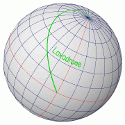 |
Meridians and Parallels, which also maintain constant true
directions may be considered as special cases of the rhumb line.
Any other rhumb line eventually spirals towards the nearest pole, forming a
loxodromic curve.
For example, a navigator located on the Equator who starts to travel a constant
NW course (270°) and keeps this course at any location along his track.
Eventually he will arrive at the North Pole and not - as one would maybe expect -
at his point of departure after circumnavigating the Earth.
To circumvent the Earth and arrive at his point of departure, the navigator
would have to travel along a great circle, but generally, a great-circle track
is not a track of constant course.
|
For the navigator, the track distance along a rhumb-line is an important piece
of information needed for example to determine the time-of-arrival at some
point ahead or to determine the current average travelling speed.
In a standard nautical chart, which is based on a
conformal Mercator Projection, a rhumb-line track
is a straight line and the distance of a rhumb-line segment - or course
line - can be easily determined. For this purpose, the length of the rhumb-line segment
in the chart is transferred onto the latitude scale on the left or right side of the chart
(in about the same Latitude as the rhumb line is located) and the corresponding
number of Latitude minutes-of-arc can be readily determined.
For getting the distance, remember that one minute-of-arc on the Latitude scale,
corresponds to one nautical mile.
These are fundamental properties of the Mercator chart. Due to the underlying
conformal projection, course and distance between two arbitrary
points can be easily determined. On the chart, a straight line is drawn through the two
points. The angle of this track-line with a vertical meridian line is the course to be sailed.
The distance can be determined by translating the length of the track-line on the
left- or right side Latitude scale and read the length in minutes-of-arc. Distances
in Mercator charts can be determined without any explicit knowledge of the scaling
factor of the chart.
Rhumb-line distances and courses may also be calculated mathematically.
This may be useful e.g. for determining the loxodrome distance of long tracks
covering more than one chart. Also for determining the loxodrome course
of transatlantic journeys this mathematical approach may be useful.
Please go to the "notes on loxodrome calculations"
to read more on this topic.
To examine the difference between loxodrome tracks and the corresponding great-circle tracks
the following interactive pages may be used:
Speed
Speed is rate of motion, or travelled distance per unit of time. A knot
(kn) is defined as a speed of 1 nautical mile per hour.
The speed of a vessel is determined by a "log".
Speed is an important piece of information for dead reckoning navigation
(from "deductive" or "ded" reckoning), a technique based on estimating speed
and time to estimate the distance the vessel has travelled.
With the sailed course, the displacement of the vessel over several time
intervals can be recorded.
Starting from a port of departure, this successive recording allows to keep
track of intermediate and current, "deduced" positions.
In the days of Columbus and Magalhães, dead reckoning was the
only known method of navigation to estimate a position in the middle of the
ocean. In these days navigators were very skilled in estimating the speed
of their vessel even without using a log. Time on board of a ship was kept
with sand glasses. Also logs for determining speed were operated with sand
glasses.
|