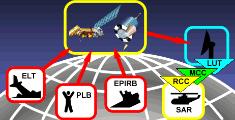
COSPAS-SARSATBesides INMARSAT, the COSPAS-SARSAT satellite system is another part of the space segment of the Global Maritime Distress and Safety System (GMDSS). COSPAS-SARSAT is an international satellite-based Search-and-Rescue system established by Russia, Canada, USA, Denmark and France to locate emergency radio beacons transmitting on 406 MHz. In contrast to INMARSAT, the COSPAS-SARSAT system has been conceived to cover also the remote polar regions of Sea Area 4. System ConceptThe basic COSPAS-SARSAT concept is illustrated below.
The system is composed of:
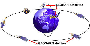
Satellite ConfigurationThe COSPAS-SARSAT system space segment consists of SAR signal processors (SARP) aboard of satellites, which can detect and process the distress signals transmitted by emergency beacons operating on 406 MHz. In order to provide world-wide coverage, the COSPAS-SARSAT system uses complementary satellite systems. The system currently consists of:
But it is investigated to add a new capability to the COSPAS-SARSAT system
called MEOSAR (Medium Earth Orbit Search and Rescue satellites).
This system will put SAR processors aboard the GPS satellite
constellation and the Galileo positioning system constellation.
MEOSAR satellites will be able to send information (e.g. distress
acknowledgment) back to the distress radio beacon via the
GPS or Galileo downlink.
The LEOSAR System
Up until mid-2007, two of the LEOSAR satellites were COSPAS satellites provided and operated by the Russian Federation. However, they were decommissioned on 6 August 2007, and currently (2008), the American NOAA Polar Operational Environmental Satellites (POES) and the EUMETSAT MetOp-A are the only LEOSAR satellites in service.
LEOSAR satellites are monitored by 44 world-wide distributed
LEOLUTs (low Earth orbit local user terminals).
The LEOSAR satellites operate in a store-and-forward mode
for 406 MHz signals - they store distress signals and forward
them to the next LEOLUT ground station they overfly.
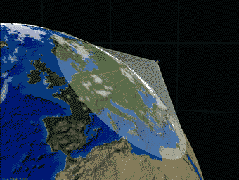
This technique results in two different coverage modes for the
LEOSAR system: local coverage and global coverage. Many regions on Earth are covered in local mode, but this depends on the current satellite positions and the local coverage is not continuous. Therefore, global coverage mode may often result in a shorter alerting time. As the beacon message is recorded and stored in the satellite memory by the first satellite pass which detected the beacon, the waiting time is not dependent upon the satellite achieving simultaneous visibility with the LEOLUT and the beacon. Consequently, the time required to produce alerts is considerably reduced. Once a 406-MHz distress signal is detected and stored by a satellite, the satellite will send this data to all LEOLUTs it may contact for 24 hours.
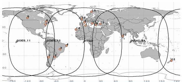
The animated graphic above depicts two beacons: the yellow beacon is detected in global mode only whereas the red beacon is detected in both local and global modes. The GEOSAR SystemCOSPAS-SARSAT has demonstrated that the current generation of COSPAS-SARSAT 406-MHz beacons could be detected using search and rescue instruments on board geostationary satellites. The GEOSAR system consists of 406-MHz repeaters carried on board various geostationary satellites and the associated ground facilities called GEOLUTs which process the satellite signal. Geostationary satellites orbit the Earth at an altitude of 36000 km, with an orbit period of 24 hours, thus appearing fixed relative to the Earth at approximately 0 degrees latitude (i.e. over the equator). A single geostationary satellite provides GEOSAR uplink coverage of about one third of the globe, except for polar regions. Therefore, three geostationary satellites equally spaced in longitude can provide continuous coverage of all areas of the globe between approximately 70° North and 70° South latitude. SARP are currently (2010) installed on the following 5 geostationary satellites:
The GEOSAR satellites are currently (2010) monitored by about 17 GEOLUTs
(Geostationary Earth Orbit Local User Terminals).
A GEOLUT is a ground receiving station in the Cospas-Sarsat System that
receives and processes 406-MHz distress beacon signals which have been
relayed by a GEOSAR satellite.
Due to the extremely large continuous coverage footprint provided by each
geostationary satellite, GEOLUTs are able to produce near instantaneous
alerting over extremely large areas.
However, due to the fact that the satellite remains stationary with respect
to distress beacons, GEOLUTs are not able to determine beacon locations
using Doppler processing techniques.
In view of this, 406-MHz beacons with location protocols allow for the
encoding of position data in the transmitted 406-MHz message,
thus providing for quasi-real time alerting with position information
via the GEOSAR system.
The following Table summarizes the LEOSAR and GEOSAR features and capabilities:
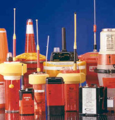
Emergency Position Indicating Radio Beacon (EPIRB)EPIRBS are for use in maritime applications and are designed to operate with the COSPAS-SARSAT system. From 2009 on, the COSPAS-SARSAT system will detect and locate only distress beacons operating at 406 MHz. Service for the older beacons operating at 121.5 MHz will terminate on 1. February 2009. But 406-MHz EPIRBs will continue to transmit a 121.5-MHz "homing" signal after activation, allowing overflying aircrafts and rescue crafts to locate the vessel in distress.
Beacon technical information
There are two categories of 406-MHz EPIRBs:
The 406-MHz data channel is 170 kHz wide and centred at 406.05 MHz. On this channel, a burst of digital data is transmitted with a bit rate of 400 bps using phase modulation. Each transmission consists of a 160 ms CW preamble followed by a data message. The data message is either a 112-bit "short" message (280 ms) or a 144-bit "long" message (360 ms) both including full identification and position information. The operating life time of the beacons will be at least 24 hours in activated mode at a temperature of -20°C. An auxiliary transmitter (homing transmitter) can be included in the 406-MHz beacon to enable SAR forces to home on the distress beacon. Testing EPIRBs406 MHz EPIRBs can be tested through its self-test function, which is an integral part of the device. 406-MHz EPIRBs can also be tested inside a container designed to prevent its reception by the satellite. Testing a 406-MHz EPIRB by allowing it to radiate outside such a container is illegal. Battery Replacement406-MHz EPIRBs use a special type of lithium battery designed for long-term low-power consumption operation. Batteries must be replaced by the date indicated on the EPIRB label using the model specified by the manufacturer. It should be replaced by a dealer approved by the manufacturer. If the replacement battery is not the proper type, the EPIRB will not operate for the duration specified in a distress. Disposal of EPIRBs
Guidelines for disposal of EPIRBs have been developed by the International
Maritime Organisation (IMO) in conjunction with COSPAS-SARSAT.
This guideline includes the request that retailers and boat-owners should
ensure that when an EPIRB needs to be disposed of, the satellite EPIRB
should be made inoperable, by removing its battery and returning
it to the manufacturer. If the EPIRB is returned to the manufacturer
with the battery still installed, it should be wrapped in tin foil to
prevent inadvertent transmission of signals during shipment. Registration of 406 MHz EPIRBsProper registration of 406-MHz satellite emergency position-indicating radio beacon (EPIRB) is mandatory and necessary in order for the beacon distress to be forwarded to the appropriate Maritime Rescue Coordination Centres (MRCCs). Registered emergency information will be used by the RCCs to verify that a distress situation exists, and in arranging appropriate rescue efforts. EPIRB alerts picked up by the GEOSAR satellite system will be relayed to the MRCCs well before the international COSPAS-SARSAT satellite can provide location information. If the EPIRB is properly registered, the MRCC will be able to use the registration information to immediately begin action on the case. If the EPIRB is unregistered, a distress alert may take as much as two hours longer to reach the MRCC over the COSPAS-SARSAT satellite system. If an unregistered EPIRB transmission is abbreviated for any reason, the satellite will be unable to determine the EPIRB's location, and the MRCC will be unable to respond to the distress alert. The registration information is entered into the Beacon Registration Database maintained by NOAA/NESDIS. If your EPIRB is activated, your registration information will be sent automatically to the appropriate SAR Rescue Coordination Center (RCC) for response. One of the first things the RCC watch standers do is attempt to contact the owner/operator at the phone number listed in the database to determine if the vessel is en-route (thus ruling out the possibility of a false alarm due to accidental activation or EPIRB malfunction), the intended route of the vessel if underway, the number of people on board, etc., from a family member. If there is no answer at this number, or no information, the other numbers listed in the database will be called to attempt to get the information described above needed to assist the RCC in responding appropriately to the EPIRB alert. Obviously, it is very important to keep the registered data in the EPIRB database up to date. If any of the registered EPIRB data (owner, vessel, address, emergency phone numbers, ...) is changed, the responsible owner MUST re-register the EPIRB. If an EPIRB is sold, the former owner should make sure that the purchaser re-registers the EPIRB, or he may be made responsible if it later becomes activated. Sources | ||||||||||||||||||||

| Cover << Sail Away << GMDSS << . | . >> SART | last updated: 07-Mar-2010 |