Introduction
An Earth-bound observer can only view a small section of the globe at a
time. Therefore, it is not possible to tell from a direct observation that
the Earth is a sphere.
The Greek philosophers were the first to theorize that the Earth was
round. Originally they concluded that the Earth could only be a sphere
because that, in their opinion, was the "most perfect" shape. Scholars
like Pythagoras in 500 BCE based their belief on observations about the
way the altitudes of stars varied at different places on the Earth and
how ships appeared on the horizon. As a ship returned to port, first its
mast tops, then the sails, and finally its hull gradually come into view.
Aristotle, who lived 300 BCE, observed that the Earth cast
a round shadow on the Moon.
The Greeks gradually calculated the general size and shape of the Earth.
They also created the grid system of Latitude and Longitude, so that with
these two coordinates any point on the Earth could be located.
While working in Alexandria, around 200 BCE, Eratosthenes
 experimentally determined quite accurate the circumference of the Earth.
He prepared numerous maps of the world as it was known by the people of his time.
The illustration on the right is one of the best available reconstructions
of a world map according to Eratosthenes.
experimentally determined quite accurate the circumference of the Earth.
He prepared numerous maps of the world as it was known by the people of his time.
The illustration on the right is one of the best available reconstructions
of a world map according to Eratosthenes.
The map featured a main East to West "parallel" and a main North to South
"meridian" intersecting in the city of Rhodos.
The idea of the basic "meridian" passing through the cities of Syene, Alexandria and Rhodos was
established since the days of Aristole, but Eratosthenes was the first geographer to introduce this system of orthogonal grid
lines for the purpose of fixing positions on Earth.
More than 3 centuries later, around 150 CE, Claudius Ptolemy, a Greek geographer,
mathematician, and astronomer, continued the work of Eratosthenes and compiled
an encyclopaedia of the ancient world from the data collected in the archives
of a legendary library in Alexandria, Egypt.
His eight-volume Geography included extensive maps of the known world,
all based on a curved globe.
Unfortunately, learning and intellect went out of fashion in Europe
between 400 and 1200 CE.
Much of the knowledge of the Greek was lost to western society with the advent
of the gloomy period known as the Dark Ages.
Sea monsters and Vikings ruled the seas, and ships that ventured too far from
shore were sure to fall off the edge of a flat Earth. Maps made in that
time were based on religious beliefs or superstitions, not on observations,
calculations, or scientific inquiry.
After 1250, map making in Europe took a more scientific form again. Land
maps and nautical charts were produced for travellers and traders using
measurements and observation rather than mythology and literary sources.
The Middle Ages slowly progressed into the Age of Discovery.
Meanwhile, the Arab world had preserved Ptolemy's Geography. Ptolemy's
works were rediscovered by the western world and translated into Latin.
Ptolemy's map projections explaining how to represent a sphere on a flat
piece of paper enabled cartographers and explorers to chart the newly-discovered
lands and seas. And the invention of the printing press made it possible
for more people to use, circulate, and refine maps.
Christopher Columbus' voyage in 1492 confirmed that the Earth was round.
Magellan's crew proved the fact definitively by circling the globe on a
three-year voyage from 1519-1522. Map making joined hand in hand with the
Age of Discovery pushed by the promising trading opportunities in India,
China and Indonesia.
The Spanish and Portuguese expeditions in the late 15th century in Africa and
 South America, clearly had a military character. The Dutch and English
nautical expeditions starting in the 16th century to India and to the Spice
Islands north of Australia, already had a more trading character and led
to an increasing sea traffic. These journeys demanded for a better charting
and documentation of ports and sea ways.
South America, clearly had a military character. The Dutch and English
nautical expeditions starting in the 16th century to India and to the Spice
Islands north of Australia, already had a more trading character and led
to an increasing sea traffic. These journeys demanded for a better charting
and documentation of ports and sea ways.
During the Spanish and Portuguese expeditions, charts had military
status. However when the English and Dutch fleets commanded by private
investors and traders, took over control of the oceans, also chart making
became an important part of the business of the Dutch, English and German
trading companies.
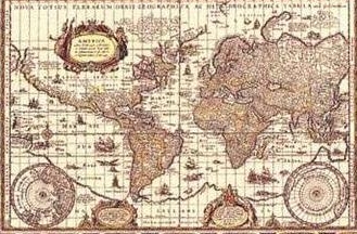
With the beginning of the 17th century, nautical information was vividly
exchanged over the trading ports of western Europe. Sea ways were documented
and the geographical information steadily updated by the famous chart mappers
of the 17th century like Gerardus Mercator, Abraham Ortelius. This was
the beginning of modern charting but the basic system dates back to the
days of Eratosthenes and Ptolemy.
|