Position and Coordinates
 |
One of the primary tasks in navigation is finding one's position
referring to some known locations.
The knowledge about position is important for save navigation
specifically to avoid hazards, to estimate drift due to leeway
and current and also simply for checking whether the vessel
is still 'on-track'.
Additionally, the information on position and current travelling
speed allows to make estimations on the remaining distance and
'time-en-route' to the destination.
|
Eratosthenes (ca. 276 BCE - ca. 195 BCE) was
the very first geographer to introduce a system of orthogonal grid lines for the
purpose of fixing positions on Earth.
These virtual grid lines cover the surface of the Earth and serve as coordinate
system allowing a unique determination of each location on the surface of the Earth.
The primary elements of this ancient orthogonal coordinate system are
Meridians of Longitude and Parallels of Latitude.
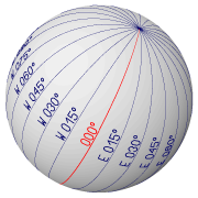
Meridians of Longitude
The Meridians of Longitude - or short Meridians - are the grid lines that
run exactly North-South. A Meridian starts at the North Pole and ends at
the South Pole. Each Meridian is the exact half of a great circle, which
includes the North Pole and South Pole.
Meridians are also defined by the intersection of the Earth's surface
with a plane including the axis of rotation of the Earth.
|
For the naming of Meridians a reference or Prime Meridian is required.
Since October 1884, the meridian of the Royal Observatory of Greenwich (London)
has been adopted as the Prime Meridian designated 000° longitude.
Other Meridians are labelled according to the angle between
the local and the Prime Meridian measured at one of the poles.
Meridians East of the prime meridian of Greenwich are labelled "E" 000°
through 180° longitude. Meridians West from Greenwich are labelled "W"
000° through 180° longitude.
The label of the meridian line passing through our current location
tells us how far East or West we are away from the Prime Meridian.
Since Meridians converge to the poles, they cannot be parallel to
each other. This is an important issue for chart making, which requires a
special procedure to map the spherical surface of the Earth onto a flat chart.
|
|
As late as 1881, there were 14 different Prime Meridians being used on
topographic survey maps. This heavily obstructed the exchange of geographical
data and the compatibility of maps and charts. The increasing importance
of the trading by seaways finally forced the adoption of an international
agreement on the "Zero-Longitude Meridian". This was settled on the "International
Meridian Conference" of 1884, by which the Meridian line passing through
the Greenwich Observatory near London was adopted as Prime Meridian.
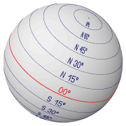
Parallels of equal Latitude
The Parallels of equal Latitude - or short Parallels - are the grid lines
that run East-West, orthogonal to the Meridians.
Parallels are defined by the intersection of the Earth's surface with a
plane orthogonal to the axis of rotation of the Earth.
The Equator is the special Parallel separating the Earth in a northern
and a southern hemisphere. It is used as reference for measuring Latitude
and is designated 00° latitude.
All Parallels, except for the Equator, are small circles.
Each Parallel is named according to the angular distance of the Parallel
above or below the Equator. The angular distance is measured along an arbitrary
Meridian. Parallels are labelled from the Equator to the Poles from 00°
through 90°. Latitudes North of the Equator are prefixed with "N" - Latitudes
South of the Equator are prefixed with "S".
The label of the Parallel passing through our current location tells
us how far North or South of the Equator we are.
|
|
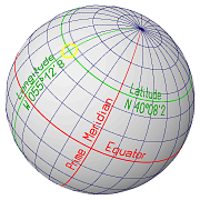
Position
Each location on the surface of the Earth is uniquely defined by the pair
of local meridian and local parallel of latitude passing through
this location. The local meridian tells us how far East or West we are away
from the Prime Meridian and the local parallel tells us how far North or South
we are away from the Equator.
|
In nautical navigation, a position is given in the following form:
  N  40° 08'2    (Latitude)
  W 055° 12'8    (Longitude)
This is the position of the location indicated by the intersection of
the local Meridian and the local Parallel on the globe on the right.
The Latitude is prefixed with "N" (North) or "S" (South) according
to a location on the northern or southern hemisphere.
The Longitude is prefixed with "E" (East) or "W" (West) depending on
whether the location is east or west of the Prime Meridian of Greenwich.
|
 |
Notice that the degree value for the Longitude is conventionally quoted
with 3 digits in the range of 000° through 180°.
A precision of 0.1 minutes of arc (about 200m) is normally sufficient
for indicating a position.
Seconds of arc (") are not used except for very precise position
specifications (e.g. the position of local hazards).
Satellite-based navigation systems will give positions down to 0.001
minutes of arc (about 2m).
When using mathematical formulas - e.g. to calculate the distance between
two locations - the following sign conventions are used instead of
the prefixes: East and North values have a positive sign; West and South
values have a negative sign.
|