NAVTEX Safety InformationNAVTEX is an acronym for NAVigational TEXt messages. It implements an international automated service for dissemination of navigational and meteorological warnings and forecasts, as well as urgent marine safety information to ships. NAVTEX is one of the basic components of the Global Marine and Distress Safety System (GMDSS). The information system was developed to provide a low-cost, simple, and automated means of receiving this information aboard ships at sea within approximately 200 nautical miles of shore. NAVTEX stations are operated by the Coast Guard authorities all around the world. There are no special user fees associated with receiving NAVTEX broadcasts. The reports are in English language no matter which part of the world the information is being received. System Overview
The international NAVTEX system operates world-wide on a single fixed frequency of 518 kHz (MF).
This enables simple and cheap receiver hardware.
NAVTEX reports are classified in different categories such as distress, search and rescue,
navigational and meteorological reports.
The NAVTEX receiver can be programmed to receive only specific stations and only
certain message subjects. This way only the relevant information for a certain
location and situation is displayed. Since all NAVTEX coast stations transmit on the same frequency
(518 KHz) world wide, each NAVTEX Station is allocated a specific 10-minute time
slot in a four-hour schedule.
This way it is guaranteed that in each time slot only one station is transmitting
thus preventing transmission interference of adjacent NAVTEX stations which would
corrupt all messages sent simultaneously.
It is important understand that NAVTEX is a medium-wave
transmission system for which an appropriate aerial is required and the reception
is also very susceptible to the RF noise generated on the vessel.
The 500kHz frequency band uses groundwave propagation, but can follow the
curvature of the Earth, so it is not restricted to line of sight use.
However, transmission ranges are notably greater over the sea than over land
and signal strength in harbours and in some near coastal areas such as in bays and
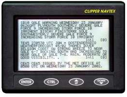
inlets may be very poor. On the chart below, the light blue areas roughly indicate the regions that are within the range of at least one Navtex Station. 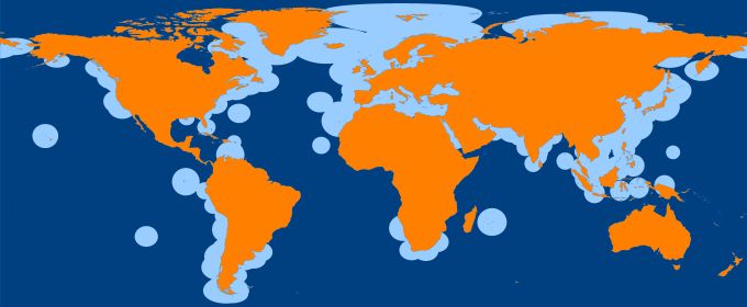 Format of NAVTEX messagesAll broadcasts on 518 kHz are in English (International requirement). Broadcasts on 490 kHz may be in English, but more likely in the national language of the country providing the broadcast. For example, all NAVTEX stations in France broadcasting on 490 kHz are in the French language. NAVTEX message example:
Message Start and End Characters Each message starts with the four characters "ZCZC" and ends with four "NNNN" characters.Message Header B1B2nn Every NAVTEX message has information within the four-character message header:
For example, "SE45" in NAV-AREA I, indicates that the message is transmitted from Niton
(B1 = S), and the message is a meteorological forecast
(B2 = E). 4209.5 kHz using FEC mode
Thus the heading indicates which NAVTEX station broadcasts it (B1),
the type of information (B2) and a sequential number of
the message (nn). The following table shows the different message categories associated with the B2 character (subject category) in the heading of a NAVTEX broadcast
On a standard NAVTEX receiver compatible for use within the GMDSS regulations
it should not be possible to reject messages with a B2 character
A (Navigational warnings), B (meteorological warnings) and D (Search and
rescue information). But note that although category L can be programmed out,
the information broadcast in this class may also be of interest to small vessels. Technical InformationSystem Details
NAVTEX broadcasts are primary made on the international medium frequencies of 518 kHz USB
using narrow-band direct printing (NBDP). The characters are encoded using the 7-bit
CCIR 476 character set and basic error detection is enabled by employing forward error
correction (FEC).
NAVTEX is broadcast using a data mode called SITOR-B (known as AMTOR in the amateur radio world).
The modulation format used for SITOR-B is a binary frequency-shift keying (BFSK) modulation,
with a frequency shift of 170 Hz on a centre frequency of 1700 Hz (mark=1615Hz,space=1785Hz).
The receiver 6 dB bandwidth should be between 270-340 Hz.
The data rate is 100 baud, which allows for a net character rate of about 5 characters per second. SITOR-B
The data format used for broadcasting NAVTEX messages is known as SITOR-B, which is based
on the more general RTTY format. SITOR-B transmits each character in a message twice to gain reliability. If the receiver detects an error in the first character, it uses the copy. If both characters are garbled, the receiver cannot detect the transmitted character and will indicate this with an error character (usually "*"). Each character is transmitted twice but in an interleaved mode with four-characters delay. The first transmission (DX) of a specific character is followed by the transmission of four other characters, after which the retransmission (RX) of the first character takes place, allowing for time-diversity reception of 280 ms: four characters with 7 bit per character and 10 ms per bit (100 Baud).
The transmit scheme:
DX      A   B   C   D   E   F   G ...      first transmission of characters
RX        x   x   A   B   C   D   ...      retransmitted characters (4 char. delay)
---   ----------------------------------
TX      A x B x C A D B E C F D G ...      characters in interleaved transmission
Development of the NAVTEX service in the United Kingdom and beyondNotice: This text is based on information that appeared in The Marine Observer, - a journal produced by the "Meteorological Office (Marine Division)" NAVTEX is an acronym for NAVigational TEXt messages. The technology for the dissemination of these text messages via a simple radio-telex system has been about for some considerable time, certainly since the late 1970s when the Post Office Coastal Radio Station at Cullercoats in the North-East of England commenced broadcasting weather forecasts and gale warnings for the North Sea and most of the English Channel shipping forecast areas from Fair Isle to Plymouth on what was then referred to as a temporary radio teletype broadcast. Apart from a change of name from the Post Office Coastal Radio Station Cullercoats, to British Telecom International Coastal Radio Station Cullercoats in the early 1980s the temporary service continued with reports coming in of its success. In April 1983 the service was declared as an operational service alongside those provided via the conventional means of the MF Morse broadcasts and those via the marine radio-telephony service. On 1st October 1983 the service was extended to the BT coastal radio station at Portpatrick. The weather information broadcast from Portpatrick included forecasts and a gale-warning service for the western sea areas of the UK, including Fair Isle in the north and all the western coastal sea areas from Lundy in the South to South-East Iceland in the North. During 1985, NAVTEX broadcasts were started via Land End Radio. This broadcast included warnings and forecasts for the English Channel, the Irish Sea and all the sea areas in the South-West approaches included in the main shipping forecast. However, reports suggested that the site at Lands End was not ideal for the intended area of coverage, and so the NAVTEX facility at Lands End was moved about a year later, in 1986, to the BT International coastal radio station at Niton on the Isle of Wight. By 1987, interest in NAVTEX was growing and NAVTEX services were being successively introduced in other countries. Gradually the information was extended from just weather to cover all the Marine Safety Information (MSI) in the bulletins. Also, the service on 518kHz was formalised in the Radio Regulations and in the World Administrative Radio Conference for Mobile Services. In 1994, the 2nd edition of the NAVTEX Manual was produced. This has only just been superceded with a new edition coming into force in 2013. NAVTEX was incorporated into the regulations for the Global Maritime Distress and Safety System (GMDSS), which was introduced in a transitional phase from 1992 to 1999, after which it became mandatory under Chapter V of the SOLAS regulations. From 1993, all SOLAS vessels were required to carry a NAVTEX receiver that always listened on 518kHz - if it was desired to receive on one of the other frequencies, a dual receiver system was required. NAVTEX - SOLAS complianceVessels obliged to carry NAVTEX equipment within the
GMDSS regulations must have the receiver switched on and tuned to the 518 kHz
frequency continuously, and if access to the new national frequency is required then
a second receiver is required. |
| Cover << Sail Away << Marine Radio Communication << . | . >> Navtex Stations | last updated: 26-Oct-2016 |