Abel Janszoon Tasman (1603-1659)
Spice Trade and the Dutch "United East-India Company" (VOC)
During the 16th century, the Spice trade was dominated by the Portuguese who used Lisbon
as a staple port. Before the Dutch Revolt, Antwerp had played an important role as a
distribution center in northern Europe, but after 1591 the Portuguese used an
international syndicate of the German Fuggers and Welsers, and Spanish and Italian
firms that used Hamburg as its northern staple, to distribute their goods, thereby
cutting out Dutch merchants.
At the same time, the Portuguese trade system was unable to supply growing demand,
in particular the demand for pepper. The demand for spices was relatively inelastic,
and the lagging supply of pepper therefore caused a sharp rise in pepper prices at the time.
Likewise, as Portugal had been "united" with the Spanish crown, with which the
Dutch Republic was at war, in 1580, the Portuguese Empire became an appropriate target
for military incursions. These three factors formed motive for Dutch merchants to enter
the intercontinental spice trade themselves at this time. Finally, a number of Dutchmen
like Jan Huyghen van Linschoten and Cornelis de Houtman obtained first hand knowledge
of the "secret" Portuguese trade routes and practices, thereby providing opportunity.
The stage was thus set for Houtman's four-ship exploratory expedition to Banten,
the main pepper port of West Java, where they clashed with both the Portuguese and
indigenous Indonesians. Houtman's expedition then sailed east along the north coast
of Java, losing twelve crew to a Javanese attack at Sidayu and killing a local ruler
in Madura. Half the crew were lost before the expedition made it back to the Netherlands
the following year, but with enough spices to make a considerable profit.
In 1598, an increasing number of new fleets were sent out by competing merchant groups
from around the Netherlands. Some fleets were lost, but most were successful, with some
voyages producing high profits. In March 1599, a fleet of eight ships under Jacob van Neck
was the first Dutch fleet to reach the "Spice Islands" of Maluku. The ships returned to
Europe in 1599 and 1600 and the expedition made a 400 percent profit.
In 1600, the Dutch joined forces with the local Hituese (near Ambon) in an anti-Portuguese
alliance, in return for which the Dutch were given the sole right to purchase spices from Hitu.
Dutch control of Ambon was achieved in alliance with Hitu when in February 1605, they prepared
to attack a Portuguese fort in Ambon but the Portuguese surrendered.
In 1613, the Dutch expelled the Portuguese from their Solor fort, but a subsequent Portuguese
attack led to a second change of hands; following this second reoccupation, the Dutch
once again captured Solor, in 1636.
East of Solor on the island of Timor Dutch advances were halted by an autonomous and powerful
group of Portuguese Eurasians called the Topasses. They remained in control of the Sandalwood
trade and their resistance lasted throughout the 17th and 18th century, causing West Timor
to remain under the Portuguese sphere of control.
At the time, it was customary for a company to be set up only for the duration of a single voyage,
and to be liquidated on the return of the fleet. Investment in these expeditions was a very
high-risk venture, not only because of the usual dangers of piracy, disease and shipwreck,
but also because the interplay of inelastic demand and relatively elastic supply of spices
could make prices tumble at just the wrong moment, thereby ruining prospects of profitability.
To manage such risk the forming of a cartel to control supply would seem logical.
This first occurred to the English, who bundled their forces into a monopoly enterprise,
the East-India Company in 1600, thereby threatening their Dutch competitors with ruin.
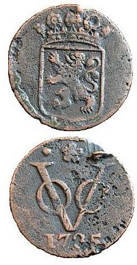
In 1602, the Dutch government followed suit, sponsoring the creation of a single
"United East-Indies Company (VOC)" that was also granted a monopoly over the Asian trade.
The charter of the new company empowered it to build forts, maintain armies, and conclude
treaties with Asian rulers.
It provided for a venture that would continue for 21 years, with a financial accounting only
at the end of each decade.
In 1603, the first permanent Dutch trading post in Indonesia was established in Banten,
West Java and in 1611, another was established at Jayakarta (later 'Batavia' and then 'Jakarta').
In 1610, the VOC established the post of Governor General to enable firmer control of their
affairs in Asia.
To advise and control the risk of despotic Governors General, a Council of the Indies
(Raad van Indië) was created. The Governor General effectively became the main administrator
of the VOC's activities in Asia, although the Heeren XVII, a body of 17 shareholders representing
different chambers, continued to officially have overall control.
VOC headquarters were in Ambon for the tenures of the first three Governors General (1610-1619),
but it was not a satisfactory location. Although it was at the centre of the spice production areas,
it was far from the Asian trade routes and other VOC areas of activity ranging from Africa to Japan.
A location in the west of the archipelago was thus sought; the Straits of Malacca were strategic,
but had become dangerous following the Portuguese conquest and the first permanent VOC settlement
in Banten was controlled by a powerful local ruler and subject to stiff competition from Chinese
and English traders.
Diplomatic agreements in Europe in 1620 ushered in a period of cooperation between the Dutch
and the English over the spice trade.
This ended with a notorious, but disputed incident, known as the 'Amboyna massacre', where ten
Englishmen were arrested, tried and beheaded for conspiracy against the Dutch government.
Although this caused outrage in Europe and a diplomatic crisis, the English quietly withdrew
from most of their Indonesian activities (except trading in Bantam) and focused on other
Asian interests.
In 1640, the VOC obtained the port of Galle, Ceylon, from the Portuguese and broke the latter's
monopoly of the cinnamon trade. In 1658, Gerard Pieterszoon Hulft laid siege to Colombo, which was
captured with the help of King Rajasinghe II of Kandy. By 1659, the Portuguese had been expelled
from the coastal regions, which were then occupied by the VOC, securing for it the monopoly over
cinnamon. To prevent the Portuguese or the English from ever recapturing Sri Lanka, the VOC went
on to conquer the entire Malabar Coast from the Portuguese, almost entirely driving them from
the west coast of India. When news of a peace agreement between Portugal and the Netherlands
reached Asia in 1663, Goa was the only remaining Portuguese city on the west coast.
In 1652, Jan van Riebeeck established an outpost at the Cape of Good Hope (the southwestern tip
of Africa, currently in South Africa) to re-supply VOC ships on their journey to East Asia.
This post later became a full-fledged colony, the Cape Colony, when more Dutch and other
Europeans started to settle there.
By 1669, the VOC was the richest private company the world had ever seen, with over 150 merchant
ships, 40 warships, 50,000 employees, a private army of 10,000 soldiers, and a dividend payment
of 40% on the original investment.
Early Life
| 1603 |
|
Abel Janszoon Tasman was born at Lutjegast, near Groningen, in the Netherlands.
He received a sufficient education to enable him to become a skilled navigator.
Tasman entered the service of the Dutch East-India Company in 1632 or 1633 and
made his first voyage of exploration to Ceram Island (now Seram, Indonesia)
as captain of the Mocha in 1634. He had a narrow escape from death, when in
an incautious landing several of his companions were massacred by people of Ceram.
After spending some time in warlike and anti-smuggling operations he returned
to Holland in 1637.
He sailed for the Indies again in 1638 as skipper of a flute, taking his wife with him.
From the outset he was treated as one of the most reliable skippers there.
He was at first employed in military and trading voyages, but in 1639 was appointed
second-in-command, under Quast, of two ships which set out in June to find islands
believed to lie east of Japan.
He returned in November from this search. Despite a disastrous death-roll on it,
he offered to repeat the search, but was sent instead on trading voyages to Japan
and Cambodia.
|
First Voyage: 1642
| 1642 |
|
Anthony van Dieman, as governor-general of commerce at Batavia and member of the
Council for the Indies, continued and expanded the groundwork of his predecessor
for exploration of the region.
Landfalls to this time (1636) had largely been happenstance, though from them, a
significantly complete picture of the north and west of the continent of Nova Hollandia
(Australia) could be mapped. However, many questions on the geography of the area were
opened and much subsequent Pacific exploration would be guided by those questions.
The Brouwers Route
The Brouwer Route was a route for sailing from the Cape of Good Hope to Java.
The Route took ships south from the Cape into the Roaring Forties, then east
across the Indian Ocean, before turning northwest for Java.
Thus is took advantage of the strong westerly winds for which the Roaring Forties
are named, greatly increasing travel speed.
It was devised by the Dutch sea explorer Hendrik Brouwer in 1611, and found to halve
the duration of the journey from Europe to Java, compared to the Arab and
Portuguese monsoon route, which involved following the coast of East Africa
northwards, sailing through the Mozambique Channel and then across the Indian Ocean,
sometimes via India.
By 1616 the Brouwer Route was compulsory for Dutch VOC sailors.
The English trialled it in 1621, and initially thought it a great success,
but the second English ship to use the route, the Tryall, incorrectly judged
the longitude, sailed too far east before turning north, and was wrecked
on the Tryal Rocks off the northwest coast of Australia.
The English then avoided the route for the next two decades.
The Brouwer Route played a major role in the discovery of the west coast of Australia,
and the very large numbers of ships that were wrecked along that coast.
The Pool expedition
Pool was directed to sail to Arnhemland (west side of the Gulf of Carpentaria), then
eastward across the expanse of water along the northern coastline of Nova Hollandia
previously explored by the Duyfken (1606) and the Pera and Arnhem (1623).
The northern coastline of the Australian continent was believed to be an extension
of New Guinea, as notes of Luis Váez de Torres' passage through Torres Strait
in 1607, remained buried in Spanish archives.
Pool was to sail south along this coast to discover its nature. It was possible that
the expedition would sail into Pieter Nuyts Land - the coast of southern Austalia,
identified and named, during the cruise of the Gulden Zeepaert in 1627 -
then continue on to Frederick de Houtman's "Abrolhos" (west coast of Australia).
Pool was then to sail along the coast where Pelsaert had marooned his mutineers
and collect them, if found. Additionally, Pool should also locate Trial Rocks
(off the northwest coast of Australia) and better define them, before returning
to Batavia.
All along during the voyage, strategical reports of watering and refreshing locations
should be made.
However, Pool's expedition ended prematurely when its commander was killed by natives
in New Guinea, and the ships returned.
The Quast expedition
Following the abortive Pool cruise, van Dieman was not dissuaded. His
plans became equally ambitious in other directions. In 1639 he sent another
expedition, this time into the North Pacific, toward Japan to search for
reputed shores of gold and silver. Two ships were outfitted and dispatched
under the command of Matthijs Hendrickszoon Quast. The captain of the other
ship was Abel Tasman who had entered the service of the Dutch East-India
Company in 1632 or 1633 and had proven to be a reliable captain.
The results of the North Pacific efforts were relatively insignificant
and the ships returned with a loss of 41 men from a complement of 90.
Scurvy was the great problem.
Despite the disappointed results, Quast's and Tasman's journals convinced
the Company Directors there were possibilities worthy of further exploration
in the region.
The Tasman expedition
In addition to the very supportive administration under van Dieman, the
Dutch had a most capable theoretical geographer in Frans Visscher. Visscher
reviewed the known regions and competently designed the scope for further
expeditions to solve the great southland problem and support Dutch
interests in the region.
With van Dieman's administrative support, Visscher, the strategy developer,
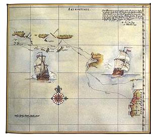
and Tasman, the seaman and navigator an expedition was implemented. Tasman
was given two ships - the Heemskerck and Zeehaen - and the
following instruction:
Sail first to Mauritius, then south into 52 or 54 degrees south latitude,
searching for the southern continent. Turn east and travel into the longitude
of the eastern edge of New Guinea or of the Solomon Islands.
If it was believed prudent and with possible rewards, Tasman could sail
east only to the longitude of the islands of St Francis and St Peter, then
north to meet them, then eastward along the coast to determine its extent.
Along this coast he should turn north if there proved to be a channel through
it. Once through the channel, Tasman should head west to locate the coast
of the southland, leading him northward to the land called Eendrachtsland.
Seeming unlikely a channel would lead Tasman toward Eendrachtsland, greater
weight was placed on continued eastern passage. Should it seem logical,
Tasman could continue to the Chilean coast, discovering an advantageous
route by which Dutch interests could snatch trade from the Spanish in this
world region.
In any event, Tasman should use the southeast trade winds to make for
the Solomon Islands from his most easterly reach. Finally, as Tasman coasted
the northern side of New Guinea, he should seek a southerly passage through
it, which would take him to Cape Keerweer and on eastward to Eendrachstsland.
Tasman was not to let on the importance placed on silver and gold, should
he encounter possible trading sources, and he was to treat all natives
encountered in the most friendly and unintimidating manner possible.
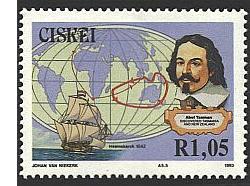
In accordance with Visscher's directions, Tasman sailed first to Mauritius
and arrived there on 5 September 1642.
Mauritius was chosen as a turning point because of the prevailing winds and
also the crew could be fed well on the island; there was plenty of fresh water
and timber to repair the ships.
After a four week stay on the island both ships left on 8 October.
After one month it started to snow and hail and Tasman changed course more north.
Part of the western shore of the continent was already known to the Dutch,
but no one had gone as far as Pieter Nuyts.
Intending to sail eastward at the southern latitude of 52 or 54 degrees,
it became evident early on that weather would not permit this. It was decided
to sail along the 44th and 40th parallels and as the two ships reached
the longitude of the islands of St Peter and St Francis, there appeared
no intention of following the southern coast of Peter Nuyts Land east.
Instead the ships stayed more south.
On 24 November 1642 Abel Tasman sighted the west coast of Tasmania, north
of Macquarie Harbour.
He named his discovery Van Diemen's Land after Anthony van Diemen.
Variable weather made exploration of the eastern coast of Van Dieman's
Land difficult. Seeking shelter in a large bay, Tasman put into a cove
he called Storm Bay (now Adventure Bay).
On the 1st of December quieter water and storm abatement allowed the
ships to anchor at Green Island and put ashore for supplies at what is
now known as Blackman's Bay. Later a crew member posted a Dutch flag, claiming
possession. Not finding good water, Tasman moved his ships northward on
December 4th to search for it.
After some exploration, Tasman had intended to proceed in a northerly direction
but with an unfavourable north wind he decided to steer east.
On the 13th of December 1642 he saw land again, having reached the shore
of the south island of New Zealand. The following sea and weather identify
this shore as one treacherous to unwary sailors. Tasman managed to
work north until able to round the point Cook would later call Cape Farewell
and anchoring in quieter water inside the western end of what today is called
Cook's Strait.
Tasman called this anchorage Murderer's Bay for the incident which followed.
One of the Dutch small boats was rammed by a native (Maori) canoe and three
Dutchmen killed. Little other of consequence occurred, except that Tasman
determined he would be unable to make friendly terms with the local population.
After sailing east, Tasman determined he was in the mouth of a great bay
and he had a strong, following wind. He turned west and then north along
the western coast of the North Island, then past (and naming) Cape Maria
van Dieman, the northwest tip of the North Island.
It appears Tasman was not wholly convinced he had been in a bay and
that perhaps on leaving Murderer's Bay there was exit to the east and on
to Chile. Resolution of the channel between the two islands was made by
Cook in 1769.
Tasman named this land "Staaten Landt", on the belief it may be a continuation
of that land at the southern American continent named such by Le Maire.
Tasman's need for fresh water increased as he left this new land. His
ship's committee agreed to run north and eastward to 17 degrees South latitude
and locate islands described earlier by Le Maire. In the track Tasman encountered
four islands on 19 January 1643. These islands were of the Tonga group,
where he was able to obtain water.
Determined that he was well enough east of Le Maire's islands, Tasman
sailed northwest to locate them. On the 6th of February he found himself
amidst many islands and water breaking over shoals. He was in the Fiji
group and these islands did not appear on his maps. Islands recorded as
being 800 miles to the west caused Tasman to question his position. The
long cruise may have lead to compiled miscalculations which caused him
to think he was in a place differently from where he actually was. This
issue lead Tasman to decide to return to Batavia and the ship's committee
agreed.
Should he sail west and south of the known portion of the island of
New Guinea? This route was unknown and carried the danger of being blown
against a shore from which it would be too difficult to retreat.
The alternative was to take the known (and safe) northerly track past New Guinea.
Worsening weather and the scepticism over the ship's position made the decision
obvious for Tasman and Visscher. They would take the northerly route.
For nearly two weeks the overcast weather made it impossible for Tasman
to take positioning sites to determine his location. The weather had been
wet throughout February and most of March and the contingent was relieved
when the winds changed and conditions brightened. At the end of March land
was sighted and Tasman named the multitude of islands Ontong Java.
On April 1st Tasman rounded Cape Santa Maria, which was believed to be an extension
from the island of New Guinea, until Dampier determined it was part of
the island group he recognized as New Britain. Tasman was now in waters
well enough known by Dutch sea captains and knew how to return to Batavia.
However, Tasman had been tasked at the outset of the voyage with exploring
the north coast of New Guinea - should he reach it - and seeking a passage
through it and south to Cape Keerweer. There is no such passage and at
the end of May Tasman reached the western edge of New Guinea. From there,
he sailed back to Batavia, arriving on 14 June, ending his 10 month voyage.
Though this voyage was spectacular by the reckoning of Dutch exploration
in the period, it was deemed to have been relatively fruitless and created
little excitement for the Dutch East-India Company. There were no new trading
partnerships opened and there were no major resource treasures found, which
would enhance the company. Furthermore, Tasman had not proven passage through
the south ocean to Chile as was originally outlined, though reaching east
from Cape Maria Van Dieman did seem promising. However, the sailing skills
of Tasman and the strategies of Visscher were significantly highly regarded
that both men figured in further Dutch exploration planning. |
Second Voyage: 1644
| 1644 |
|
The Dutch interest in entering the south sea and accessing the Spanish
shores off Chile lead to planning of another voyage for Tasman and Visscher.
However, in the last months of 1644 the Dutch were encumbered with a war
with the Portuguese and a voyage to prove the route was never undertaken.
Uninhibited by the war was an unbroken interest in resolving several issues
around New Guinea and New Holland that had not been resolved during
the first Tasman expedition. Tasman and Visscher were outfitted for this
new venture with three ships, Limmen, Zeemeuw and Bracq
and that started in February 1644.
The exploration was to examine the "great bay" on the southern side of
New Guinea by anchoring on the western coast of the northern part of what
is now Cape York (Australia) and send the Bracq eastward into the
"bay" searching for a passage into the south sea. Next, Tasman was
to sail south along the west coast (Cape York Peninsula) and to follow the
coast to determine if it would open into the south sea. He was further
to determine if Van Dieman's Land (Tasmania) was the southern part of New Guinea or
a part of Pieter Nuyts Land or an island. If he should reach Van Dieman's
Land through such a channel, Tasman was to sail to St Francis and St Peter,
then westward and northward along the west coast of New Holland to the
end of Eendrachtsland.
However, if there was no passage south from the starting point near
New Guinea, then Tasman should follow the coast of the Gulf of Carpentaria
wherever it may lead. Should it lead westward to the Abrolhos, Tasman should
try to locate the sunken chest from the Batavia then steer northward to
look for the men marooned by Pelsaert and to find a watering place for
ships bound to Batavia from Europe. Tasman should then sail into Arnhem
Land and determine its geography and nature, before finally locating islands
between Timor and New Holland.
Little is known of the actual voyage, except that the northern coast
line was followed as it now is mapped today. From Eendrachtsland Tasman
returned to Batavia in August 1644. He had sailed the coast, but had done
little exploration of the land he passed. Tasman had noted the miserable
existence of the natives along the coast, but had not sought gold and silver
or trade possibilities the land would offer.
The Dutch East Indies Company, which sponsored Tasman's voyage necessarily
responded to the stockholders and Tasman's travel had used money and returned
nothing of stockholder interest. Tasman's efforts were not regarded highly
by the Company.
|
Later Career
| 1647 |
|
Although he was rewarded with the rank of commander and was made a member
of the Council of Justice of Batavia, his second voyage was also a disappointment
to the company because it had failed to reveal lands of potential wealth and
trading opportunities.
Despite this outcome, Abel Tasman remained in the service of the VOC.
In 1647 he commanded a trading fleet to Siam and in May 1648 he was in charge
of an expedition sent to Manila to try to intercept and loot the Spanish
silver ships coming from America, but he had no success and returned to Batavia
in January 1649.
In November 1649 he was charged and found guilty of having in the previous year
hanged one of his men without trial, was suspended from his office of commander,
fined, and made to pay compensation to the relatives of the sailor.
On 5 January 1651 he was formally reinstated in his rank and spent his remaining
years at Batavia.
By 1653 he had left the company's service, but still lived, apparently as
one of its wealthiest citizens, in Batavia where he died 6 years later,
probably in October 1659.
|
|